

Recommended Software
ArtMoney 7.39.2
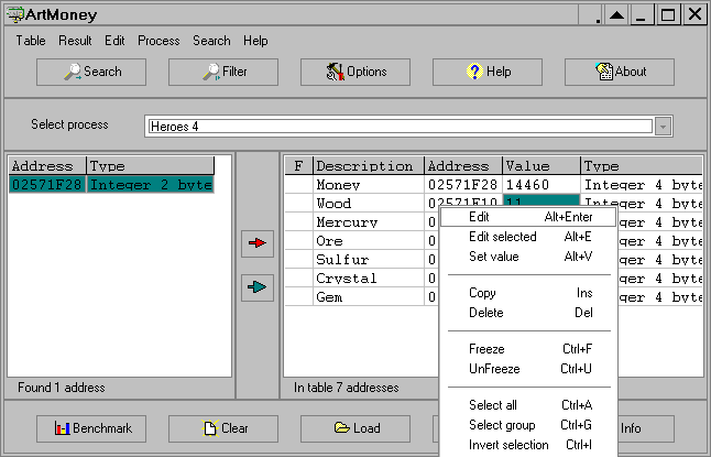
ArtMoney is a cheating program you can use for all games. ArtMoney can make a troublesome game easier to win by helping you find the memory address where a desired quantity (like amount of money) is located so you can change that quantity. In spite of its title, ArtMoney actually allows you to...
DOWNLOADSoftware Catalog
 Android Android |
Business & Productivity Tools |
| Desktop |
Developer Tools |
| Drivers |
Education |
| Games |
Home & Personal |
| Internet & Networking |
Multimedia & Design |
| Operating Systems |
Utilities |


Points Import for IntelliCAD Download
Points Import for IntelliCAD 1.0
Points Import for IntelliCAD is a Point Text file import plug-in for IntelliCAD powered applications. This plug-in gives IntelliCAD powered applications the ability to import point data from text files.
Point data is commonly stored in plain text file as a series of x, y and z coordinates, separated by a comma, space, tab, semicolon or a custom separator. These text files may also contain other information about the points such as point number and point descriptions. Moreover, points from a survey may be stored in the Northing, Easting, Elevation format. Points Import for IntelliCAD extracts the point information from text files and creates point entities in the active drawing.
Points Import for IntelliCAD supports the following point file formats:
X, Y, Z
Number, X, Y, Z
X, Y, Z, Description
Number, X, Y, Z, Description
Northing, Easting, Elevation
Number, Northing, Easting, Elevation
Northing, Easting, Elevation, Description
Number, Northing, Easting, Elevation, Description
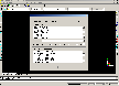
Points Import for IntelliCAD is very easy to use as it adds a new command to the IntelliCAD powered application called "PointsImport". Simply type "PointsImport" at the command prompt and the "Point File" dialog (shown below) will be will displayed where you can select a Point file to import into the active drawing.
Size: 1003.9 KB | Download Counter: 6
If Points Import for IntelliCAD download does not start please click this:
Download Link 1
Can't download? Please inform us.
Related Software
 NC Import for IntelliCAD - NC Import for IntelliCAD is a Numeric Control NC program file import plug-in for IntelliCAD powered applications. This plug-in gives IntelliCAD powered applications the ability to import geometric data from NC program files.
- STL Import for IntelliCAD - STL Import for IntelliCAD is a Stereolithography STL file import plug-in for IntelliCAD powered applications. This plug-in gives IntelliCAD powered applications the ability to import geometric data from ASCII and Binary STL files.
- OBJ Import for IntelliCAD - OBJ Import for IntelliCAD is an Alias Wavefront OBJ file import plug-in for IntelliCAD powered applications. This plug-in gives IntelliCAD powered applications the ability to import geometric data from OBJ files.
- Terrain for AutoCAD - Terrain for AutoCAD is a terrain modeling plug-in for AutoCAD. This plug-in gives AutoCAD the ability to create a terrain mesh from a set of unordered points, lines, polylines and splines.
- HPGL Import for IntelliCAD - HPGL Import for IntelliCAD is a Hewlett Packard Graphics Language (HPGL) plot PLT file import plug-in for IntelliCAD powered applications. This plug-in gives IntelliCAD powered applications the ability to import geometric data from HPGL PLT files.
- STL Export for IntelliCAD - STL Export for IntelliCAD is a Stereolithography STL file export plug-in for IntelliCAD powered applications. This plug-in gives IntelliCAD powered applications the ability to export geometric data to ASCII and Binary STL files.
 SEVENPAR (English) - SEVENPAR calculaties exact parameter sets for the Spatial Helmert or Molodensky Transformation with seven or three parameters, which are used for accurate geodetic datum shifts between different reference systems for coordinate transformations.
 Data Loader - A simple yet powerful tool to Export, Import, Migrate and Convert data between different databases and delimited flat text CSV files. Supports Saving & Scheduling of Sessions and Repository.
 VIGps - - you can show a currentl GPS data;
- you can open any of scanned maps;
- you can calibrate the scanned maps yourself by two calibration points only;
- calibrations are stored automatically for every map;
VIGps - - you can show a currentl GPS data;
- you can open any of scanned maps;
- you can calibrate the scanned maps yourself by two calibration points only;
- calibrations are stored automatically for every map; progeCAD 2007 Standard - ProgeCAD IntelliCAD natively reads and writes AutoCAD DWG files, no need for conversion! Industry standard AutoCAD Commands. AutoCAD Menu, Script, Font Compatibility, AutoLISP Compatibility!
 Top Downloads
- PDF Info
- PDF Vista
- Zortam Mp3 Media Studio
- KB Piano
- Name Maker LE
- Photo Effects
- Universal Converter
- Wavepad Audio Editor
- Easy FlashMaker (SWF Creator)
- Media Encoder Console

New Downloads
- Zortam Mp3 Media Studio
- Bandicam
- Usability Studio
- MakeUp Pilot
- HyperCam
- Wire Pilot
- Vocal Remover
- IncrediShow
- CollageIt
- A Ruler for Windows

New Reviews
- jZip Review
- License4J Review
- USB Secure Review
- iTestBot Review
- AbsoluteTelnet Telnet / SSH Client Review
- conaito VoIP SDK ActiveX Review
- conaito PPT2SWF SDK Review
- FastPictureViewer Review
- Ashkon MP3 Tag Editor Review
- Video Mobile Converter Review
Actual Software
| Link To Us
| Links
| Contact
Must Have
| TOP 100
| Authors
| Reviews
| RSS
| Submit


