

Recommended Software
CloudBerry Explorer for Amazon S3 1.5.1.39
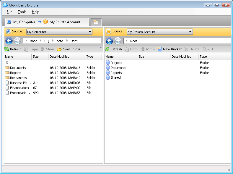
CLOUDBERRY EXPLORER FOR AMAZON S3 CloudBerry S3 Explorer makes managing files in Amazon S3 EASY. By providing an industry leading user interface (GUI) to Amazon S3 accounts, files, and buckets, CloudBerry lets you manage your files on cloud just as you would on your own local computer. New...
DOWNLOADSoftware Catalog
 Android Android |
Business & Productivity Tools |
| Desktop |
Developer Tools |
| Drivers |
Education |
| Games |
Home & Personal |
| Internet & Networking |
Multimedia & Design |
| Operating Systems |
Utilities |


Geodaten German Admin (Deutsch) Feedback System
Geodaten German Admin (Deutsch) Info
License: Demo | Author: C. Killet Software Ing.-GbR | Requirements: All systems
Geodata of the Federal Republic Germany with municipalities, postal codes, telefone preselections. Suitable for branch searches, periphery searches and distance computations. Georeferences as Gauss Krueger, UTM and geographic coordinates. ORTREF: 12.500 geocoded cities and municipalities. ORTGEM: Allocation of 12.500 cities and municipalities to the localities. ORTTLREF: 63.000 geocoded local parts. ORTTLGEM: Allocation of 63.000 local parts to the localities. PLZREF: 32.000 geocoded postal zip codes of the zip areas and p.o. box areas. PLZGEM: Allocation of 32.000 postal zip codes to the localities. VORWREF: 14,500 geocoded telephone local area preselections. VORWGEM: Allocation of 14.500 local area preselections to the localities. KREIS: 450 Local districts. REGBEZ: Governmental districts. LAND: Counties of the German Federal Republic. The download contains a test composition of the data of 5 local districts and the exact data description. A freeware conversion program CONVERT for producing of different data formats can be downloaded from the site http://www.killetsoft.de/p_cona_e.htm. Here the data fields of the table ORTREF are specified as example: Place name, municipality key, geographical longitude and geographical latitude in degree notation, geographical longitude and geographical latitude in degree / minute / secund notation, Gauss Krueger easting, Gauss Krueger northing, UTM easting, UTM northing, new postal zip code (significant digits), old postal zip code, number of inhabitants, No. of the telephone directory, No. of the topographic card 1:25000, UNLOCODE, type of place,date of record change.
Notice: * - required fields
C. Killet Software Ing.-GbR Software
 TOPOWIN - TOPOWIN is a state-wide register of the German topographic cartographies and of localities with geo references in different coordinate systems. It also is a topographic information system.
 ORTWIN - ORTWIN is a program for the inquiry of localities in Germany. It finds postal zip codes, telephone pre selections, coordinates. It performs perimeter searches and distance calculations. It finds landscapes, natural units, snow- and wind load zones.
 SEVENPAR (English) - SEVENPAR calculaties exact parameter sets for the Spatial Helmert or Molodensky Transformation with seven or three parameters, which are used for accurate geodetic datum shifts between different reference systems for coordinate transformations.
 TRANSDAT (English) - TRANSDAT Geosoftware executes coordinate transformations and geodetic datum shifts between lots of coordinate and reference systems of America, Australasia, Europe, Germany spec. and world-wide. The NTv2 standard with national grid files is supported
 TRANSDAT (Deutsch) - TRANSDAT Coordinate Conversion supports thousands of coordinate systems and geodetic datum shifts, user-defined systems, INSPIRE, NTv2, BeTA2007, GPS, continental drift, many file systems, ESRI-Shape and much more with highest accuracy.
 GEODLL32 (Deutsch) - In the DLL GeoDLL geodesic functions like 2D and 3D coordinate transformation, datum changes, meridian strip changes, NTv2, distance calculation, map functions, Digital Elevation Models ec. are contained to bind them into own WINDOWS applications.
 Top Downloads
- Excel List Compare
- DTM Data Generator
- Import Wizard
- LabDB
- Toad for MySQL
- DBF Viewer 2000
- AWStats
- TOAD for Oracle Freeware
- Scribes
- Access Password Get

New Downloads
- DTM Data Generator
- DTM DB Stress
- LabDB
- Full Convert Enterprise
- Small Library Organizer Pro
- AWStats
- Abetone-Datenbank
- Reportizer Viewer
- DBF Converter
- Exportizer

New Reviews
- jZip Review
- License4J Review
- USB Secure Review
- iTestBot Review
- AbsoluteTelnet Telnet / SSH Client Review
- conaito VoIP SDK ActiveX Review
- conaito PPT2SWF SDK Review
- FastPictureViewer Review
- Ashkon MP3 Tag Editor Review
- Video Mobile Converter Review
Actual Software
| Link To Us
| Links
| Contact
Must Have
| TOP 100
| Authors
| Reviews
| RSS
| Submit


