Must Have | TOP 100 | Authors | Reviews | RSS | Submit

Recommended Software

MS Project Viewer

MS Project Viewer 2.8

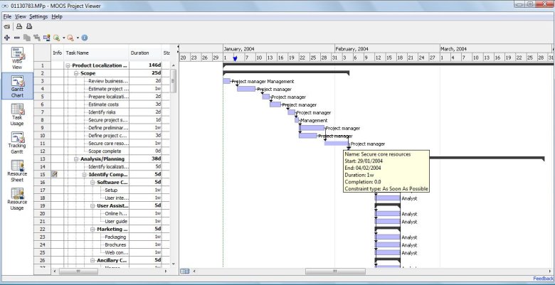
MOOS Project Viewer is a Microsoft Project viewer that can open any MS Project file type (.mpp, .mpt, .mpx, .xml) for any Microsoft Project version (2000, 2003, 2007, 2010). Available views: WBS, Gantt chart, task sheet, resource sheet, resource usage, tracking Gantt. It is running on any Java...

DOWNLOAD


All | Free Longitude Related Software Downloads

VIGps 1.0

VIGps Thumbnail
GPS Navigator with using a scanned maps and possibility to open a lot of maps together. - you can show a current GPS data (Speed, Direction, Longitude, Latitude, Time, Date, Height); - you can open any of scanned maps (in a "bmp" or "dib" format); - you can calibrate the scanned maps...

DOWNLOAD GET FULL VER Cost: $12.00 USD, 9.00 EUR
License: Demo
Size: 4.6 MB
Download Counter: 10

Released: December 24, 2005 | Added: December 27, 2005 | Viewed: 1893
 

Geodaten German Admin (Deutsch) 11.00

Geodaten German Admin (Deutsch) Thumbnail
Geodata of the Federal Republic Germany with municipalities, postal codes, telefone preselections. Suitable for branch searches, periphery searches and distance computations. Georeferences as Gauss Krueger, UTM and geographic coordinates. ORTREF: 12.500 geocoded cities and municipalities. ORTGEM:...

DOWNLOAD GET FULL VER Cost: $195.00 USD, 150.00 EUR
License: Demo
Size: 313.3 KB
Download Counter: 3

Released: March 08, 2007 | Added: March 11, 2007 | Viewed: 1422
 

EasyMap VCL 2.2

EasyMap VCL Thumbnail
EasyMap VCL is a Delphi/C++Builder components set for creating your own GIS-related solutions without MapInfo, MapX, MapObjects, WinGIS and so on. EasyMap VCL allows to add following functionalities in Delphi/C++Builder application: - MIF/MID vector maps displaying in Longitude/Lantitude...

DOWNLOAD GET FULL VER Cost: $79.95 USD
License: Shareware
Size: 2.3 MB
Download Counter: 13

Released: December 02, 2004 | Added: December 05, 2004 | Viewed: 1756
 

RoboGEO 5.0

RoboGEO Thumbnail
Geocode digital images with latitude, longitude, altitude, and direction information when collecting GIS field data. RoboGEO stamps this information onto the actual photo or writes it to the EXIF headers, allowing you to permanently geotag and link your photos to the GPS coordinates. All writing...

DOWNLOAD GET FULL VER Cost: $34.95 USD
License: Demo
Size: 6.4 MB
Download Counter: 14

Released: September 22, 2006 | Added: September 25, 2006 | Viewed: 1548
 

Geo Data International Admin (English) 1.03

Geo Data International Admin (English) Thumbnail
Geodata of international countries with locals, municipalities and postal codes. Georeferences as UTM- and geographic coordinates (WGS84, ETRS89). Suitable for branch searches, periphery searches and distance computations. These countries are available: Albania, Andorra, Belgium, Bosnia,...

DOWNLOAD GET FULL VER Cost: $195.00 USD, 150.00 EUR
License: Demo
Size: 151.6 KB
Download Counter: 23

Released: August 16, 2006 | Added: August 19, 2006 | Viewed: 1614
 

ZIP Pointer 2.0

ZIP Pointer Thumbnail
Lookup USA and Canada towns by ZIP, postal code or name and show them on a North American map. This helps you to check customer information, verify postal addresses, and reduce credit card fraud. Using the program is simple. Just enter a ZIP Code, and the program gives you the matching city,...

DOWNLOAD GET FULL VER Cost: $29.95 USD, 24.95 EUR
License: Shareware
Size: 5.5 MB
Download Counter: 6

Released: September 30, 2005 | Added: January 04, 2012 | Viewed: 1364
 

ZylGPSReceiver.NET 2.00

ZylGPSReceiver.NET Thumbnail
ZylGPSReceiver.NET is an event driven .NET component that communicates with a GPS receiver. It returns latitude, longitude, altitude, speed, heading and many other useful parameters of the current position and the parameters of the satellites in view. The component is extended to calculate...

DOWNLOAD GET FULL VER Cost: $99.99 USD
License: Shareware
Size: 1.1 MB
Download Counter: 110

Released: July 24, 2008 | Added: August 06, 2009 | Viewed: 2087
 

1 Moon Above 4.3

1 Moon Above Thumbnail
A unique and stunning 3D Windows screensaver featuring the Moon, correctly positioned in relation to the Earth and Sun. See the current phase of the Moon, or accelerate time and see how the phase changes over the coming days and months! You have the option of seeing the positional details for the...

DOWNLOAD GET FULL VER Cost: $14.95 USD
License: Shareware
Size: 1.3 MB
Download Counter: 23

Released: March 10, 2006 | Added: April 01, 2006 | Viewed: 2402
 

World Saver 3D 3.4

World Saver 3D Thumbnail
A unique, stunning, fully-featured 3D Windows screensaver by 3D Wonders. It features a beautifully rendered 3D world slowly spinning against a backdrop of nebulae and stars, with the Sun and Moon correctly positioned in relation to the Earth. Additional visual effects including clouds,...

DOWNLOAD GET FULL VER Cost: $14.95 USD
License: Shareware
Size: 938.5 KB
Download Counter: 9

Released: March 10, 2006 | Added: March 30, 2006 | Viewed: 1684
 

Zip Code Genie 1.01

Zip Code Genie Thumbnail
Zip Code Genie looks up and fills in address data (city name, state name, area code, county, FIPS number, latitude, longitude, etc.) automatically for you, based on the zip codes that you type. Works with your existing word processing documents, spreadsheets, and database forms. Compatible with...

DOWNLOAD GET FULL VER Cost: $49.95 USD
License: Shareware
Size: 2.1 MB
Download Counter: 8

Released: September 15, 2003 | Added: September 18, 2003 | Viewed: 1889
 

ZylGPSReceiverAX 3.10

ZylGPSReceiverAX Thumbnail
ZylGPSReceiverAX is an an award-winning ActiveX control that communicates with a serial GPS receiver. It returns latitude, longitude, altitude, speed, heading and many other parameters of the position. This control works with any NMEA compatible receiver connected to one of the serial ports....

DOWNLOAD GET FULL VER Cost: $99.99 USD
License: Shareware
Size: 863.4 KB
Download Counter: 28

Released: May 26, 2007 | Added: August 10, 2009 | Viewed: 2126
 

ZylGPSReceiver 3.58

ZylGPSReceiver Thumbnail
ZylGPSReceiver is a Delphi/CBuilder component that communicates with a serial GPS receiver. It returns latitude, longitude, altitude, speed, heading and many other parameters of the position. This component works with any NMEA compatible receiver connected to one of the serial ports. You can...

DOWNLOAD GET FULL VER Cost: $129.99 USD
License: Demo
Size: 1.7 MB
Download Counter: 34

Released: April 20, 2009 | Added: July 28, 2009 | Viewed: 2238
 

MPMileage 2.1

MPMileage Thumbnail
Batch calculate route distances, travel times, and/or estimated costs for point-to-point routes listed in a database (Access, Excel, or ODBC). Uses Microsoft MapPoint for point locations and route calculations. Supports all of MapPoint's route options including fastest routes, shortest routes,...

DOWNLOAD GET FULL VER Cost: $75.00 USD
License: Shareware
Size: 3.1 MB
Download Counter: 7

Released: December 16, 2011 | Added: March 20, 2012 | Viewed: 3054
 

GPS.NET 2.3.20

GPS.NET Thumbnail
Develop precise, efficient, and reliable GPS software in record time with this multithreaded component for desktop and mobile devices, including PocketPC, Windows CE, Tablet PC, Smartphone and now Windows Mobile! Over fifty classes in one lightweight assembly give you unparalleled features while...

DOWNLOAD GET FULL VER Cost: $279.00 USD
License: Commercial
Size: 10.5 MB
Download Counter: 43

Released: July 15, 2008 | Added: July 19, 2008 | Viewed: 2282
 

Alcyone Ephemeris 2.5

Alcyone Ephemeris Thumbnail
Alcyone Ephemeris is an accurate and fast astronomical ephemeris calculator covering the period 3000 BC to AD 3000. It calculates heliocentric, geocentric, and topocentric positions of the Sun (Earth), Moon, planets and fixed stars in ecliptical, equatorial, and horizontal coordinates (including...

DOWNLOAD GET FULL VER Cost: $49.00 USD
License: Shareware
Size: 9.4 MB
Download Counter: 28

Released: March 24, 2006 | Added: June 09, 2006 | Viewed: 2107
 

ESRI Shapefile Plug-In for GIS.NET 2.0

ESRI Shapefile Plug-In for GIS.NET Thumbnail
ESRI shapefiles are one of the most popular spatial data formats for describing features on Earth's surface. This plug-in adds support for ESRI shapefile data in GIS.NET. Quickly load, modify and save shapefile data, including vector information (.SHP) as well as annotations (.DBF). Shapes are...

DOWNLOAD Cost: $0.00 USD
License: Commercial
Size: 5.4 MB
Download Counter: 14

Released: September 07, 2006 | Added: September 10, 2006 | Viewed: 1426
 

GridImp 2.3

GridImp Thumbnail
Imports gridded data into Microsoft MapPoint, to produce attractive data maps that resemble contour maps. Input data consists of a value that is defined for various (gridded) geographic coordinates. Common text output formats such as CSV are supported. Can handle imperfect data, holes,...

DOWNLOAD GET FULL VER Cost: $75.00 USD
License: Shareware
Size: 2.2 MB
Download Counter: 10

Released: January 02, 2007 | Added: January 05, 2007 | Viewed: 2202
 

MarshallSoft GPS Component for C/C++ 2.2

MarshallSoft GPS Component for C/C++ Thumbnail
MarshallSoft GPS Component C/C++ and .NET toolkit reads and decodes industry standard GPS NMEA 183 navigation sentences from the RS232 serial port as well as computes great circle distances and bearings. Features include: - Supports both 32-bit and 64-bit Windows. - Uses the Windows API...

DOWNLOAD GET FULL VER Cost: $115.00 USD
License: Shareware
Size: 561.6 KB
Download Counter: 21

Released: June 02, 2010 | Added: June 13, 2011 | Viewed: 2117
 

ORTWIN 8.30

ORTWIN Thumbnail
ORTWIN is a program for the state-wide inquiry of the localities, postal codes and telephone selections in Germany. It finds postal zip codes, telephone pre selections, coordinates and ground level elevations. The program determines municipal codes, local center points, car license codes,...

DOWNLOAD GET FULL VER Cost: $145.00 USD, 110.00 EUR
License: Shareware
Size: 3.6 MB
Download Counter: 8

Released: February 22, 2012 | Added: February 23, 2012 | Viewed: 2229
 

EarthWatch 4.01

EarthWatch Thumbnail
EarthWatch (for Windows) displays a graphical world clock with dynamic map image of the world showing the day and night areas, a sundial, and an almanac information panel featuring sunrise/sunset times and much more -- all in real-time or time-lapse animation. EarthWatch is informative,...

DOWNLOAD Cost: $25.00 USD
License: Shareware
Size: 3.1 MB
Download Counter: 8

Released: March 12, 2002 | Added: January 01, 2003 | Viewed: 1358
 

Software 21-40 of 44  |  Go to << Prior 1 2 3 Next >> page 


Actual Software | Link To Us | Links | Contact

Must Have | TOP 100 | Authors | Reviews | RSS | Submit