

Recommended Software
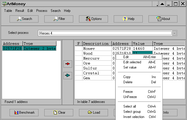
ArtMoney 7.39.2
ArtMoney is a cheating program you can use for all games. ArtMoney can make a troublesome game easier to win by helping you find the memory address where a desired quantity (like amount of money) is located so you can change that quantity. In spite of its title, ArtMoney actually allows you to...
DOWNLOADSoftware Catalog
 Android Android |
Business & Productivity Tools |
| Desktop |
Developer Tools |
| Drivers |
Education |
| Games |
Home & Personal |
| Internet & Networking |
Multimedia & Design |
| Operating Systems |
Utilities |


TiVec Download
TiVec 1.2

TiVec is a data processing program that enables the user to process Tiger Line files from the Census Bureau and convert them to MID/MIF or SHP/DBF files for use with major GIS and mapping suites. At the same time, it allows the user to select Lat/Long or Lambert projections, separate Tiger feature characteristics, smooth out data for compactness, create composite polygon files, and much more. It comes with a built-in MID/MIF and Shape file viewer, with full zooming and panning capabilities, that allows the user to immediately do a visual check for data coverage, look at multiple layers, etc.
It supports both TGR and ZIP source data archives, and has been updated to include new attributes introduced in the 2000 census release.
Size: 1.1 MB | Download Counter: 11
If TiVec download does not start please click this:
Download Link 1
Can't download? Please inform us.
Related Software
 Process Developer Enterprise Edition - Activity Mapping, flowchart mapping & document control can all be achieved via this simple tool.It helps the organization to meet the ISO 9000:2000 process mapping requirements, requires no training & can be used by anyone with Excel '97 or Later.
 Eye4Gps - GPS Mapping Software for Windows, Loading topographic maps, manage GPS devices and more. The software can be used with various map formats including: GeoTiff, BSB Nautical Charts, AutoCad DXF files, ESRI Shapefiles.
 Polymap - PolyMap is a desktop mapping program that lets you use your own data to customize the maps supplied with the program. The Map Presentation Wizard gives you a step-by-step process to customize your map and the maps legend.
 Canvas GIS Advanced (Mac) - CANVAS 9 Advanced GIS Mapping Edition: Direct support for Geographic Information System data. You can take measurements in geographic coordinates, import any popular GIS file types into unlimited numbers of automatically aligned overlapping layers.
- Canvas GIS Advanced - CANVAS 9 Advanced GIS Mapping Edition includes direct support for Geographic Information System data. Take measurements in geographic coordinates, import any popular GIS file types into unlimited numbers of automatically aligned overlapping layers.
 Pos HTML Image Mapper - Easily create HTML image maps with this friendly image mapping utility. Pos HTML Image Mapper includes WYSIWYG interface allowing you mapping images fast and easy.
 Mapyx Quo - Mapyx Quo enables you to connect your GPS to your PC. View information - elevation, distance, speed, ETA,etc... Quo supports: GE KML,GPX format,ESRI SHP,Geocaching,Garmin,Magellan,OziExplorer files and more. Includes importing your own scanned maps.
 MPSuperShape - MPSuperShape is a shape manipulation tool for Microsoft MapPoint. MPSuperShape can combine shapes, find overlaps, find boundaries, and import/export various files. MapPoint 2006, .NET Framework 2.0 (or later), and Windows XP or Vista required.
- Canvas GIS Mapping Edition - CANVAS 9 GIS Mapping Edition includes direct support for Geographic Information System data. You can take measurements in geographic coordinates, import SHAPE & GeoTIFF files into unlimited numbers of automatically aligned overlapping layers.
- Canvas GIS Mapping Edition (Mac) - CANVAS 9 GIS Mapping Edition includes direct support for Geographic Information System data. You can take measurements in geographic coordinates, import SHAPE & GeoTIFF files into unlimited numbers of automatically aligned overlapping layers.
 Top Downloads
- PDF Info
- PDF Vista
- Zortam Mp3 Media Studio
- KB Piano
- Name Maker LE
- Photo Effects
- Universal Converter
- Wavepad Audio Editor
- Easy FlashMaker (SWF Creator)
- Media Encoder Console

New Downloads
- Zortam Mp3 Media Studio
- Bandicam
- Usability Studio
- MakeUp Pilot
- HyperCam
- Wire Pilot
- Vocal Remover
- IncrediShow
- CollageIt
- A Ruler for Windows

New Reviews
- jZip Review
- License4J Review
- USB Secure Review
- iTestBot Review
- AbsoluteTelnet Telnet / SSH Client Review
- conaito VoIP SDK ActiveX Review
- conaito PPT2SWF SDK Review
- FastPictureViewer Review
- Ashkon MP3 Tag Editor Review
- Video Mobile Converter Review
Actual Software
| Link To Us
| Links
| Contact
Must Have
| TOP 100
| Authors
| Reviews
| RSS
| Submit


