

Recommended Software
ArtMoney 7.39.2
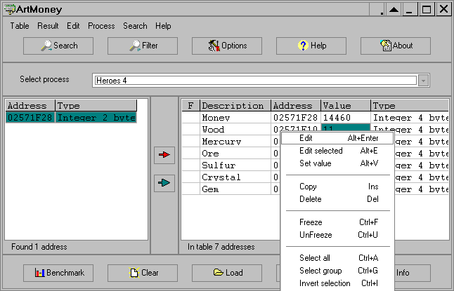
ArtMoney is a cheating program you can use for all games. ArtMoney can make a troublesome game easier to win by helping you find the memory address where a desired quantity (like amount of money) is located so you can change that quantity. In spite of its title, ArtMoney actually allows you to...
DOWNLOADSoftware Catalog
 Android Android |
Business & Productivity Tools |
| Desktop |
Developer Tools |
| Drivers |
Education |
| Games |
Home & Personal |
| Internet & Networking |
Multimedia & Design |
| Operating Systems |
Utilities |


Geodaten German Topo
Geodaten German Topo 2.04
Category:
Business & Productivity Tools / Database Management
| Author: Killet Software Ing.-GbR
DOWNLOAD
GET FULL VER
Cost: $30.00 USD, 25.00 EUR
License: Demo
Size: 50.2 KB
Download Counter: 4
Requirements: All systems
OS Support:
Language Support:
Related Software
All In One Place | Cash Registers | Coordinate | Download place | Fire place mpg | Geodetics | Geography | Geosoftware | Guide | Id3 Information | Information | Information System | Map | Measuring | Modem Registers | Pdf Information | Place | System | System Information | Topo autocad
 TOPOWIN - TOPOWIN is a state-wide register of the German topographic cartographies and of localities with geo references in different coordinate systems. It also is a topographic information system.
 TRANSDAT (English) - TRANSDAT Geosoftware executes coordinate transformations and geodetic datum shifts between lots of coordinate and reference systems of America, Australasia, Europe, Germany spec. and world-wide. The NTv2 standard with national grid files is supported
 TRANSDAT (Deutsch) - TRANSDAT Coordinate Conversion supports thousands of coordinate systems and geodetic datum shifts, user-defined systems, INSPIRE, NTv2, BeTA2007, GPS, continental drift, many file systems, ESRI-Shape and much more with highest accuracy.
 Desktop Ruler - A Virtual ruler - very useful with spreadsheets, graphic utilities and programming tools. Offers adjustable size, color
and transparency, 90 degrees rotation, scale in chosen units, and several behaviors in interaction with mouse and
screen.
Desktop Ruler - A Virtual ruler - very useful with spreadsheets, graphic utilities and programming tools. Offers adjustable size, color
and transparency, 90 degrees rotation, scale in chosen units, and several behaviors in interaction with mouse and
screen. GEODLL32 (Deutsch) - In the DLL GeoDLL geodesic functions like 2D and 3D coordinate transformation, datum changes, meridian strip changes, NTv2, distance calculation, map functions, Digital Elevation Models ec. are contained to bind them into own WINDOWS applications.
 GEODLL32 (English) - In the DLL GeoDLL geodesic functions like 2D and 3D coordinate transformation, datum changes, meridian strip changes, NTv2, distance calculation, map functions, Digital Elevation Models ec. are contained to bind them into own WINDOWS applications.
 Mapyx Quo - Mapyx Quo enables you to connect your GPS to your PC. View information - elevation, distance, speed, ETA,etc... Quo supports: GE KML,GPX format,ESRI SHP,Geocaching,Garmin,Magellan,OziExplorer files and more. Includes importing your own scanned maps.
 SEVENPAR (English) - SEVENPAR calculaties exact parameter sets for the Spatial Helmert or Molodensky Transformation with seven or three parameters, which are used for accurate geodetic datum shifts between different reference systems for coordinate transformations.
 EMAS (Electro Meridian Analysis System) - EMAS 2005 is comprised of a measuring device and application software. It uses the Ryodoraku theory which was invented in Japan and had been used for more than 50 years. It guides you in measuring 24 points on the hands and feet in just three minutes
- APFill - Ink Coverage Meter - Ink usage is usually described by the printer manufactures as so many pages of A4 using 5% coverage. This software helps you calculate ink, toner coverage on page before printing expressed as a percentage.
 Top Downloads
- Excel List Compare
- DTM Data Generator
- Import Wizard
- LabDB
- Toad for MySQL
- DBF Viewer 2000
- AWStats
- TOAD for Oracle Freeware
- Scribes
- Access Password Get

New Downloads
- DTM Data Generator
- DTM DB Stress
- LabDB
- Full Convert Enterprise
- Small Library Organizer Pro
- AWStats
- Abetone-Datenbank
- Reportizer Viewer
- DBF Converter
- Exportizer

New Reviews
- jZip Review
- License4J Review
- USB Secure Review
- iTestBot Review
- AbsoluteTelnet Telnet / SSH Client Review
- conaito VoIP SDK ActiveX Review
- conaito PPT2SWF SDK Review
- FastPictureViewer Review
- Ashkon MP3 Tag Editor Review
- Video Mobile Converter Review
Actual Software
| Link To Us
| Links
| Contact
Must Have
| TOP 100
| Authors
| Reviews
| RSS
| Submit


