

Recommended Software
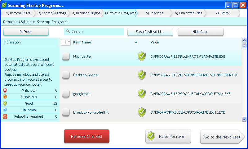
UnHackMe 7.80.0.481
The main difference between UnHackMe and other antirootkit software is its detection method. Precise double-checking for a Windows-based PC, which allows identifying and eliminating any types of malicious software. Instant tracking of malicious code in the system. UnHackMe was initially...
DOWNLOADSoftware Catalog
 Android Android |
Business & Productivity Tools |
| Desktop |
Developer Tools |
| Drivers |
Education |
| Games |
Home & Personal |
| Internet & Networking |
Multimedia & Design |
| Operating Systems |
Utilities |


GEODLL32 (English) Feedback System
GEODLL32 (English) Info
License: Shareware | Author: Killet Softwareentwicklung GbR | Requirements: 200 MHz, 256 MB Memory, 10 MB HD
GeoDLL supports the development of geodetic software on various platforms by providing geodetic functions. GeoDLL contains precise functions of the themes 2D and 3D coordinate transformation, geodetic datum shift and reference system convertion, meridian strip changing, user defined coordinate and reference systems, distance calculation, Digital Elevation Model, NTv2 handling and map function. GeoDLL enables to perform professional grade coordinate transformations in own programs: 1.The current and historical coordinate and reference systems of all countries of the European Union (EU) including the eastern extensions and the systems of non-EU countries. 2. The INSPIRE© supported European ETRS89 systems. 3. The US and Canadian State Plane Coordinate Systems (SPCS) on NAD27 and NAD83 and other coordinate systems of the North American continent. 4. The coordinate and reference systems of the Australasian continent. 5. Many coordinate and reference systems of the countries of other continents. 6. World-wide NTv2 grid file supported coordinate transformations. 7. All world-wide coordinate and reference systems in current use. 8. The German coordinate and reference systems of the old and new federal states, the 40 Prussian Soldner Land Registers, the German ‘Lagestatus’, and exact reference systems of the German federal states. User coordinate systems, local reference systems and earth ellipsoids can be defined, based on the coordinate system parameters, the semi axes of the earth and seven Helmert or three Molodenski datum parameters. GeoDLL comes with extensive documentation and is supplied as a DLL file or as C++ or CA-Visual Objects source code. The functions of GeoDLL are suitable for multithreading. The DLL is written in the C++ language. That gives very fast performance, compact code, and high stability in use.
Notice: * - required fields
Killet Softwareentwicklung GbR Software
 Graphics4VO (English) - Graphics4VO for CA-Visual Objects contains classes, methods and functions for the integration of graphic items, presentation graphics and DIB images for the display, printer, plotter, file and memory.
 Graphics4VO Examples Program (English) - Graphics4VO for CA-Visual Objects contains classes, methods and functions for the integration of graphic items, presentation graphics and DIB images for the display, printer, plotter, file and memory.
 Top Downloads
- Intellexer Summarizer
- SMS Messaging SDK
- HS NMEA GPS C Source Library
- Mime4Net: Email and Mime parser for .Net
- Windows Std Serial Comm Lib for Visual Basic
- Polyglot 3000
- Alvas.Audio
- Super 2d/3d Graph Library
- PDF Maker
- ANPOP POP3 Component Build

New Downloads
- Polyglot 3000
- PDF Security ActiveX
- .Net Grid
- PlotLab .NET
- VideoLab .NET
- HS TFTP C Source Library
- License4J
- LinqConnect
- TX Text Control ActiveX Standard
- TX Text Control ActiveX Professional

New Reviews
- jZip Review
- License4J Review
- USB Secure Review
- iTestBot Review
- AbsoluteTelnet Telnet / SSH Client Review
- conaito VoIP SDK ActiveX Review
- conaito PPT2SWF SDK Review
- FastPictureViewer Review
- Ashkon MP3 Tag Editor Review
- Video Mobile Converter Review
Actual Software
| Link To Us
| Links
| Contact
Must Have
| TOP 100
| Authors
| Reviews
| RSS
| Submit


