

Recommended Software
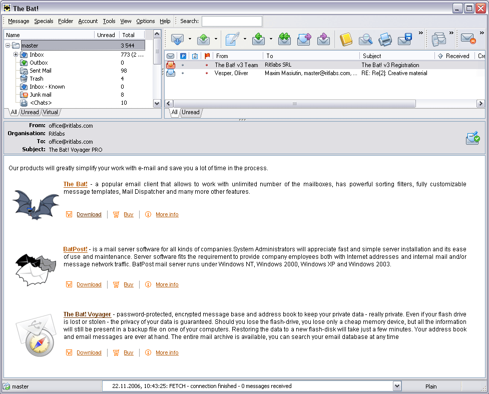
The Bat! 3.95
The Bat! is a powerful, highly configurable, yet easy to use, email client for the casual user or the power user, the home or the office. Unlimited multiple accounts and multiple users Familiar Explorer-style folders for organizing messages Easily configurable user interface with message...
DOWNLOADSoftware Catalog
 Android Android |
Business & Productivity Tools |
| Desktop |
Developer Tools |
| Drivers |
Education |
| Games |
Home & Personal |
| Internet & Networking |
Multimedia & Design |
| Operating Systems |
Utilities |


Canvas GIS Advanced
Canvas GIS Advanced 9.0.4
Category:
Multimedia & Design / Illustration
| Author: ACD Systems
DOWNLOAD
Cost: $999.95 USD, 999.95 EUR
License: Shareware
Size: 54.2 MB
Download Counter: 10
2,104 Coordinate Reference Systems
67 Operation Methods (like Mercator, Albers Conic Equal Area??¦)
1,052 Map Projections
302 Geodetic Datums
21 Angular units
45 Length units
The CANVAS 9 Advanced GIS Mapping Edition bridges the gap between dedicated GIS analysis software and generic "DTP" software. For many applications CANVAS 9 GIS Mapping Edition can now replace programs costing thousands. For the rest, CANVAS 9 GIS Mapping Edition is now the preferred "last mile" publishing companion to dedicated GIS analysis software.Files Supported include:
oMapInfo, oARC/INFO, oUSGS, Digital Line Graphs, oTIGER(Census), oMrSID (Win. only), oGML (Geography Markup Language), oSDTS (USGS Spatial Data Transfer Standard), oGIS Text oGarmin (GPS), oECW (Enhanced Compressed Wavelet Images, oS57 (IHO International Hydrographic Organization)
Requirements: Pentium III, Win 2000,XP 128 MB RAM 100 MB HD, 16-bit color, 1024x768 Res
OS Support:
Language Support:
Related Software
3d Graphics Software | Cad | Desktop Publishing | Desktop Software | Drawing Software | Engineering Software | Geotiff | Gis Positioning Software | Gis Software | Graphics Software | Hide Files Software | Presentation Software | Shape Files | Software dau-9p | Technical Drawing Software | Vector Illustration Software | Vector software | Web Graphics Software | Web Publishing Software
 Canvas GIS Mapping Edition - CANVAS 9 GIS Mapping Edition includes direct support for Geographic Information System data. You can take measurements in geographic coordinates, import SHAPE & GeoTIFF files into unlimited numbers of automatically aligned overlapping layers.
- Canvas GIS Mapping Edition (Mac) - CANVAS 9 GIS Mapping Edition includes direct support for Geographic Information System data. You can take measurements in geographic coordinates, import SHAPE & GeoTIFF files into unlimited numbers of automatically aligned overlapping layers.
- Canvas Professional Edition - CANVAS 9 is the high-performance drawing environment for professionals in business, science, and engineering. It seamlessly integrates technical drawing, image editing, page layout, web graphics & presentation features into a single application.
- Canvas Professional Edition (Mac) - CANVAS 9 is the high-performance drawing environment for professionals in business, science, and engineering. It seamlessly integrates technical drawing, image editing, page layout, web graphics & presentation features into a single application.
- Canvas GIS Advanced (Mac) - CANVAS 9 Advanced GIS Mapping Edition: Direct support for Geographic Information System data. You can take measurements in geographic coordinates, import any popular GIS file types into unlimited numbers of automatically aligned overlapping layers.
- Canvas Scientific Imaging Edition (Mac) - CANVAS 9 Scientific Imaging Edition blends native support for advanced imaging and DICOM support with Canvas' full range of vector illustration, image editing, page layout, web graphics, and desktop presentation features.
- Canvas Scientific Imaging Edition - CANVAS 9 Scientific Imaging Edition blends native support for advanced imaging and DICOM support with Canvas' full range of vector illustration, image editing, page layout, web graphics, and desktop presentation features.
 VGEdit - VGEdit is an automated vector graphics editor with powerful Raster To Vector, DXF and SVG Converters and the best choice for creating business and technology graphics.
 Sketsa - Sketsa is a cross platform vector drawing application based on SVG. Sketsa features various tools for optimizing content creation, giving designers unsurpassed support for creativity.
 CeledyDraw 2 - CeledyDraw 2 is a 2-in-1 Graphic Design and Desktop Publishing program that's ideal for use in homes, schools, and small-businesses.
CeledyDraw 2 is powerful, easy-to-use, and affordable.
CeledyDraw 2 - CeledyDraw 2 is a 2-in-1 Graphic Design and Desktop Publishing program that's ideal for use in homes, schools, and small-businesses.
CeledyDraw 2 is powerful, easy-to-use, and affordable.
 Top Downloads
- Gadwin PrintScreen
- Scanitto
- Sketsa
- AKVIS Stamp
- Edraw Max
- Mosaic Creator
- Magnifixer
- Frame from AVI
- progeCAD 2007 Standard
- True BoxShot

New Downloads
- Magnifixer
- Scanitto
- Urban Graphic
- Visual Data
- PostworkShop
- Edraw Max
- CoverME
- progeCAD 2007 Standard
- Sketsa
- True BoxShot

New Reviews
- jZip Review
- License4J Review
- USB Secure Review
- iTestBot Review
- AbsoluteTelnet Telnet / SSH Client Review
- conaito VoIP SDK ActiveX Review
- conaito PPT2SWF SDK Review
- FastPictureViewer Review
- Ashkon MP3 Tag Editor Review
- Video Mobile Converter Review
Actual Software
| Link To Us
| Links
| Contact
Must Have
| TOP 100
| Authors
| Reviews
| RSS
| Submit


