

Recommended Software
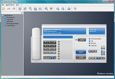
VentaFax Business 6.0
VentaFax is a full-featured fax and answering machine software with color fax support. It sends and receives faxes and turns your PC with a fax modem into a versatile answering machine with remote control and email integration. You can retrieve your fax and voice messages from any touchtone phone...
DOWNLOADSoftware Catalog
 Android Android |
Business & Productivity Tools |
| Desktop |
Developer Tools |
| Drivers |
Education |
| Games |
Home & Personal |
| Internet & Networking |
Multimedia & Design |
| Operating Systems |
Utilities |


TRANSDAT (English)
TRANSDAT (English) 13.39


Category:
Education / Language
| Author: C. Killet Software Ing.-GbR
DOWNLOAD
GET FULL VER
Cost: $170.00 USD, 170.00 EUR
License: Shareware
Size: 3.4 MB
Download Counter: 7
Requirements: 500 MHz, 500 MB Memory, 100 MB HD
OS Support:
Language Support:
Related Software
Body Transformation | Code Transformation Tech | Color Coordinates | Conversion | Coordinate | Coordinates | Datum | Fo Transformation | Geodetic | Geometric Transformation | Image Transformation | Reference | Shift | Shift calender | Shift delete | Shift planner | System | Systems | Transformation | Xsl Transformation
 GEODLL32 (Deutsch) - In the DLL GeoDLL geodesic functions like 2D and 3D coordinate transformation, datum changes, meridian strip changes, NTv2, distance calculation, map functions, Digital Elevation Models ec. are contained to bind them into own WINDOWS applications.
 GEODLL32 (English) - In the DLL GeoDLL geodesic functions like 2D and 3D coordinate transformation, datum changes, meridian strip changes, NTv2, distance calculation, map functions, Digital Elevation Models ec. are contained to bind them into own WINDOWS applications.
 TRANSDAT (Deutsch) - TRANSDAT Coordinate Conversion supports thousands of coordinate systems and geodetic datum shifts, user-defined systems, INSPIRE, NTv2, BeTA2007, GPS, continental drift, many file systems, ESRI-Shape and much more with highest accuracy.
 SEVENPAR (English) - SEVENPAR calculaties exact parameter sets for the Spatial Helmert or Molodensky Transformation with seven or three parameters, which are used for accurate geodetic datum shifts between different reference systems for coordinate transformations.
 ORTWIN - ORTWIN is a program for the inquiry of localities in Germany. It finds postal zip codes, telephone pre selections, coordinates. It performs perimeter searches and distance calculations. It finds landscapes, natural units, snow- and wind load zones.
 TOPOWIN - TOPOWIN is a state-wide register of the German topographic cartographies and of localities with geo references in different coordinate systems. It also is a topographic information system.
- Canvas GIS Mapping Edition (Mac) - CANVAS 9 GIS Mapping Edition includes direct support for Geographic Information System data. You can take measurements in geographic coordinates, import SHAPE & GeoTIFF files into unlimited numbers of automatically aligned overlapping layers.
- Canvas GIS Mapping Edition - CANVAS 9 GIS Mapping Edition includes direct support for Geographic Information System data. You can take measurements in geographic coordinates, import SHAPE & GeoTIFF files into unlimited numbers of automatically aligned overlapping layers.
- Canvas GIS Advanced (Mac) - CANVAS 9 Advanced GIS Mapping Edition: Direct support for Geographic Information System data. You can take measurements in geographic coordinates, import any popular GIS file types into unlimited numbers of automatically aligned overlapping layers.
- Canvas GIS Advanced - CANVAS 9 Advanced GIS Mapping Edition includes direct support for Geographic Information System data. Take measurements in geographic coordinates, import any popular GIS file types into unlimited numbers of automatically aligned overlapping layers.
 Top Downloads
- Random Word Generator
- Arabic School Software
- Arabic Keyboard Typing Tutor
- Amigos Spanish Puzzles
- LangOver
- Web Translator
- Alive Text to Speech
- American English Pronunciation Patterns
- SederetBrowser - Kamus Indonesia Inggris
- MultiTranse

New Downloads
- LangOver
- Web Translator
- Language Reader
- Magic Translator
- Virtual Teacher Screensaver
- Google Translate Desktop
- MultiTranse
- ProvaLingua
- Wikitup
- Linguarde

New Reviews
- jZip Review
- License4J Review
- USB Secure Review
- iTestBot Review
- AbsoluteTelnet Telnet / SSH Client Review
- conaito VoIP SDK ActiveX Review
- conaito PPT2SWF SDK Review
- FastPictureViewer Review
- Ashkon MP3 Tag Editor Review
- Video Mobile Converter Review
Actual Software
| Link To Us
| Links
| Contact
Must Have
| TOP 100
| Authors
| Reviews
| RSS
| Submit


