

Recommended Software
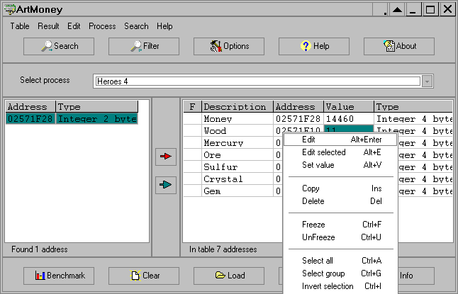
ArtMoney 7.39.2
ArtMoney is a cheating program you can use for all games. ArtMoney can make a troublesome game easier to win by helping you find the memory address where a desired quantity (like amount of money) is located so you can change that quantity. In spite of its title, ArtMoney actually allows you to...
DOWNLOADSoftware Catalog
 Android Android |
Business & Productivity Tools |
| Desktop |
Developer Tools |
| Drivers |
Education |
| Games |
Home & Personal |
| Internet & Networking |
Multimedia & Design |
| Operating Systems |
Utilities |


TOPOWIN Feedback System
TOPOWIN Info
License: Shareware | Author: C. Killet Software Ing.-GbR | Requirements: 500 MHz, 500 MB Memory, 100 MB HD
TOPOWIN is a state-wide register of the German Topographic Cartographies, the German Basic Cartography and of localities with geo references in different coordinate systems. It is also a topographic information system. In the division of planning and execution of economical and scientific projects frequently topographic documents are used. The program TOPOWIN makes information available of the official topographic cartographies and the German Basic Cartography from the entire national territory in suitable graphic views. It accomplishes different coordinate transformations and inquiries. The program was developed under co-operation of the land surveying authorities of many German Federal States. For the first time in the previous version TOPO (for DOS) and later in TOPOWIN state-wide topographic information were arranged for the data technical evaluation. The program is for consulting engineers, planning authorities and users of topographic maps a useful and versatile tool. The topographical maps of different standards, required for a project, can be determined by the entering of known parameters or by the direct selection from overview graphics and from sorted lists. By the investigation of topographical records on the basis of known places, a data base with more then 105.000 places and residential districts is available. The program TOPOWIN calculates with Gauss Krueger coordinates and Geographic Coordinates refering to the Potsdam Datum (Bessel ellipsoid with central point Rauenberg). It also works with UTM coordinates and UTMRef coordinates in the NATO standard, which refer to the datum ETRS89 (GRS80 / WGS84, geocentric).
Notice: * - required fields
C. Killet Software Ing.-GbR Software
 Geodaten German Admin (Deutsch) - Geodata of the Federal Republic Germany with municipalities, postal codes, telephone preselections. Georeferences as Gauss Krueger- UTM- and geographic coordinates. Suitable for branch searches, periphery searches and distance computations.
 ORTWIN - ORTWIN is a program for the inquiry of localities in Germany. It finds postal zip codes, telephone pre selections, coordinates. It performs perimeter searches and distance calculations. It finds landscapes, natural units, snow- and wind load zones.
 SEVENPAR (English) - SEVENPAR calculaties exact parameter sets for the Spatial Helmert or Molodensky Transformation with seven or three parameters, which are used for accurate geodetic datum shifts between different reference systems for coordinate transformations.
 TRANSDAT (English) - TRANSDAT Geosoftware executes coordinate transformations and geodetic datum shifts between lots of coordinate and reference systems of America, Australasia, Europe, Germany spec. and world-wide. The NTv2 standard with national grid files is supported
 TRANSDAT (Deutsch) - TRANSDAT Coordinate Conversion supports thousands of coordinate systems and geodetic datum shifts, user-defined systems, INSPIRE, NTv2, BeTA2007, GPS, continental drift, many file systems, ESRI-Shape and much more with highest accuracy.
 GEODLL32 (Deutsch) - In the DLL GeoDLL geodesic functions like 2D and 3D coordinate transformation, datum changes, meridian strip changes, NTv2, distance calculation, map functions, Digital Elevation Models ec. are contained to bind them into own WINDOWS applications.
 Top Downloads
- Excel List Compare
- DTM Data Generator
- Import Wizard
- LabDB
- Toad for MySQL
- DBF Viewer 2000
- AWStats
- TOAD for Oracle Freeware
- Scribes
- Access Password Get

New Downloads
- DTM Data Generator
- DTM DB Stress
- LabDB
- Full Convert Enterprise
- Small Library Organizer Pro
- AWStats
- Abetone-Datenbank
- Reportizer Viewer
- DBF Converter
- Exportizer

New Reviews
- jZip Review
- License4J Review
- USB Secure Review
- iTestBot Review
- AbsoluteTelnet Telnet / SSH Client Review
- conaito VoIP SDK ActiveX Review
- conaito PPT2SWF SDK Review
- FastPictureViewer Review
- Ashkon MP3 Tag Editor Review
- Video Mobile Converter Review
Actual Software
| Link To Us
| Links
| Contact
Must Have
| TOP 100
| Authors
| Reviews
| RSS
| Submit


