

Recommended Software

PMM Personal Memory Manager PMM70ST
Philosophy Application - PMM Personal Memory Manager v7.0 (July 2010). A philosophy of memory and the power of belief, called "Constructive Recollection" received its own software application. PMM (Personal Memory Manager) is your life-long support system to constructively recollect what you...
DOWNLOADSoftware Catalog
 Android Android |
Business & Productivity Tools |
| Desktop |
Developer Tools |
| Drivers |
Education |
| Games |
Home & Personal |
| Internet & Networking |
Multimedia & Design |
| Operating Systems |
Utilities |


OkMap Feedback System
OkMap Info
License: Freeware | Author: Gian Paolo Saliola | Requirements: Microsoft Framework 3.5
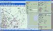
OkMap is a GPS and map software that:
-Works with vectorial maps and calibrates raster maps
-Organizes paths by creating waypoints, routes and tracks
-Uploads/downloads data to/from your GPS
-Uses altitude DEM data
-Supports GPS real-time navigation
-Sends/receives vehicles position and display tracks on maps in real time
-Provides autorouting and geocoding functions
-Supports integration with Google Maps and Earth (in 3D also)
Potential use:
-Search and rescue
-Trekking
-Off road
-Boating
-Flying
-Mountain bike
-Geocaching
-Hunting and fishing
-Finding mushrooms
-Soft air
Main features:
-Calibrate raster maps with different cartographic projections
-Create own digital maps importing / drawing shapes
-Create and manage waypoints, routes and tracks in GPX format
-Download, save and automatically georeference maps from Google Maps
-Support autorouting, geocoding and inverse geocoding functions
-Use digital terrain models to store and display elevation
-Upload / download data to / from GPS devices
-Navigate in real time through NMEA protocol
-Display Google Earth and Google Maps in current map location
-Exchange data with Google Earth and view your map in 3D
-Find nearby cache in www.geocaching.com
-Exchange data with gpsgate.com server
-Receive navigation data from remote GPS devices
-Send the current position to an OkMap remote server
-Make conversions between coordinates, datums, formats, etc..
Supported formats:
-Images: ecw, bmp, gif, jpg, png, tif and many others
-Maps: gfw, jgw, pgw, tfw, bpw (Drg maps); ecw (Earth Resource Mapping); map (OziExplorer); gmi (GpsTuner)
-Vector data: shp, dbf (Esri shape file); dcw (Digital Chart of World)
-GPS data: gpx (GPS Exchange Format); kml (Keyhole Markup Language); wpt, plt, rte (OziExplorer); loc (Geocaching) and many others formats through the software GpsBabel
-DEM data (digital earth model): hgt (SRTM-1 and SRTM-3)
Notice: * - required fields
 Top Downloads
- Outlook Message Autofill
- MyCafeCup Internet Cafe WiFi CyberCafe Software.
- PrintConductor
- eTalkup
- #1 Easy Invoice Program - Free Download
- Feet and Inches Calculator
- Euro Calculator
- Magic ASCII Studio
- Best Flobo Repair Disk
- Posterita POS

New Downloads
- PrintConductor
- Word Viewer
- Word Reader
- Absence Management System
- Word to PDF Converter
- ESBCalc Pro - Scientific Calculator
- Free PDF Converter
- HIPAA Security Rule Assistant
- Stock Quotes Pro
- Stock Predictor

New Reviews
- jZip Review
- License4J Review
- USB Secure Review
- iTestBot Review
- AbsoluteTelnet Telnet / SSH Client Review
- conaito VoIP SDK ActiveX Review
- conaito PPT2SWF SDK Review
- FastPictureViewer Review
- Ashkon MP3 Tag Editor Review
- Video Mobile Converter Review
Actual Software
| Link To Us
| Links
| Contact
Must Have
| TOP 100
| Authors
| Reviews
| RSS
| Submit


