

Recommended Software
1Click DVD Copy 5.0.2.1
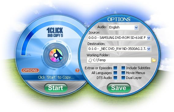
1CLICK DVD COPY™ 5 is fast and easy-to-use software for copying DVD movies. This latest version now utilizes CPRx™ error correction technology to ensure the highest level of success copying the latest generation of DVD movies.Now you can make a perfect copy of a DVD movie with just...
DOWNLOADSoftware Catalog
 Android Android |
Business & Productivity Tools |
| Desktop |
Developer Tools |
| Drivers |
Education |
| Games |
Home & Personal |
| Internet & Networking |
Multimedia & Design |
| Operating Systems |
Utilities |


OkMap Download
OkMap 8.9.2

OkMap is a GPS and map software that:
-Works with vectorial maps and calibrates raster maps
-Organizes paths by creating waypoints, routes and tracks
-Uploads/downloads data to/from your GPS
-Uses altitude DEM data
-Supports GPS real-time navigation
-Sends/receives vehicles position and display tracks on maps in real time
-Provides autorouting and geocoding functions
-Supports integration with Google Maps and Earth (in 3D also)
Potential use:
-Search and rescue
-Trekking
-Off road
-Boating
-Flying
-Mountain bike
-Geocaching
-Hunting and fishing
-Finding mushrooms
-Soft air
Main features:
-Calibrate raster maps with different cartographic projections
-Create own digital maps importing / drawing shapes
-Create and manage waypoints, routes and tracks in GPX format
-Download, save and automatically georeference maps from Google Maps
-Support autorouting, geocoding and inverse geocoding functions
-Use digital terrain models to store and display elevation
-Upload / download data to / from GPS devices
-Navigate in real time through NMEA protocol
-Display Google Earth and Google Maps in current map location
-Exchange data with Google Earth and view your map in 3D
-Find nearby cache in www.geocaching.com
-Exchange data with gpsgate.com server
-Receive navigation data from remote GPS devices
-Send the current position to an OkMap remote server
-Make conversions between coordinates, datums, formats, etc..
Supported formats:
-Images: ecw, bmp, gif, jpg, png, tif and many others
-Maps: gfw, jgw, pgw, tfw, bpw (Drg maps); ecw (Earth Resource Mapping); map (OziExplorer); gmi (GpsTuner)
-Vector data: shp, dbf (Esri shape file); dcw (Digital Chart of World)
-GPS data: gpx (GPS Exchange Format); kml (Keyhole Markup Language); wpt, plt, rte (OziExplorer); loc (Geocaching) and many others formats through the software GpsBabel
-DEM data (digital earth model): hgt (SRTM-1 and SRTM-3)
Size: 20.2 MB | Download Counter: 23
If OkMap download does not start please click this:
Download Link 1
Can't download? Please inform us.
Related Software
 HoudahGeo - One-stop photo geocoding for the Mac: Know Where you Took that Photo. Write geotags to EXIF, XMP & IPTC. See your photos in Google Earth. Share geocoded photos on Flickr and Locr.com
 RoboGEO - Geocode photos from a GPS for GIS field data collection. Stamp the images or write to the EXIF headers. Export Google Maps, KML KMZ files for Google Earth, Shapefiles (SHP), AutoCAD DXF files, or Flickr. Import from tracklogs, waypoints or GPX.
 XCBA Route Planner - Production of a passage plan prior to departure is a legal requirement. Route Planner assists in the preparation of passage plans by allowing you to prepare, calculate and print full featured passage plan.
 GPS Generator PRO - The GPS Generator PRO application is designed for providing assitance in developing, testing and debugging programs and equipment working with the NMEA-0183 protocol. This application can also be used for learning and testing navigation applications.
 Route Manager - Route Manager is a complete application that allows vending operators to easily manage and track every aspect of a vending operation. Track new and potential leads that become customers.
 ZylNMEAGenerator - ZylNMEAGenerator is a Delphi component that transforms position data in NMEA format.
You can generate complex NMEA sentences from simple data inputs. The sentences are recognized by any NMEA compatible mapping software.
ZylNMEAGenerator - ZylNMEAGenerator is a Delphi component that transforms position data in NMEA format.
You can generate complex NMEA sentences from simple data inputs. The sentences are recognized by any NMEA compatible mapping software. VIGps - - you can show a currentl GPS data;
- you can open any of scanned maps;
- you can calibrate the scanned maps yourself by two calibration points only;
- calibrations are stored automatically for every map;
VIGps - - you can show a currentl GPS data;
- you can open any of scanned maps;
- you can calibrate the scanned maps yourself by two calibration points only;
- calibrations are stored automatically for every map; GPS Time and Test - PC Clock synchronization using GPS. It can be used as NMEA and COM port tester.
The program synchronizes a PC Clock to the right time using artificial satellites.
GPS Time and Test - PC Clock synchronization using GPS. It can be used as NMEA and COM port tester.
The program synchronizes a PC Clock to the right time using artificial satellites. RouteWriter - Imports and Exports MapPoint waypoints and pushpins in route-order. MapPoint always re-arranges pushpins when it does this. Exports routes directly to Excel, or you can create a route from pushpins in a pre-determined order.
 ZylGPSReceiver - ZylGPSReceiver is a Delphi/CBuilder component that communicates with a serial GPS receiver.
This component works with any NMEA compatible receiver connected to one of the serial ports. You can use it also with USB and Bloototh devices.
ZylGPSReceiver - ZylGPSReceiver is a Delphi/CBuilder component that communicates with a serial GPS receiver.
This component works with any NMEA compatible receiver connected to one of the serial ports. You can use it also with USB and Bloototh devices.
 Top Downloads
- Outlook Message Autofill
- MyCafeCup Internet Cafe WiFi CyberCafe Software.
- PrintConductor
- eTalkup
- #1 Easy Invoice Program - Free Download
- Feet and Inches Calculator
- Euro Calculator
- Magic ASCII Studio
- Best Flobo Repair Disk
- Posterita POS

New Downloads
- PrintConductor
- Word Viewer
- Word Reader
- Absence Management System
- Word to PDF Converter
- ESBCalc Pro - Scientific Calculator
- Free PDF Converter
- HIPAA Security Rule Assistant
- Stock Quotes Pro
- Stock Predictor

New Reviews
- jZip Review
- License4J Review
- USB Secure Review
- iTestBot Review
- AbsoluteTelnet Telnet / SSH Client Review
- conaito VoIP SDK ActiveX Review
- conaito PPT2SWF SDK Review
- FastPictureViewer Review
- Ashkon MP3 Tag Editor Review
- Video Mobile Converter Review
Actual Software
| Link To Us
| Links
| Contact
Must Have
| TOP 100
| Authors
| Reviews
| RSS
| Submit


